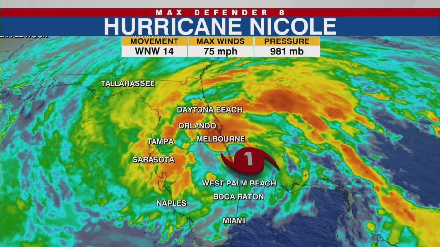
Hurricane Nicole makes landfall along Florida’s east coast

TAMPA, Fla. (WFLA) — Hurricane Nicole made landfall early Thursday morning along the east coast of Florida, on North Hutchinson Island, just south of Vero Beach.
Nicole is the first hurricane to make landfall in the US this late in the season in 40 years. It’s the third time on record a hurricane had struck Florida in November.
At landfall, Nicole had maximum sustained winds of 75 mph, making it a Category 1 hurricane. The storm was about 15 miles north-northwest of Fort Pierce, Florida, moving west-northwest at 14 mph.
In its previous advisory, the NHC said Nicole had hurricane-force winds extending outward up to 25 miles from the storm’s center, and tropical-storm-force winds extending outward up to 485 miles.
The storm is forecast to weaken as it moves across central and northern Florida into Georgia on Thursday, then across the Carolinas Friday. It will likely be a post-tropical cyclone by Friday afternoon, the NHC said.

“Do not focus on the exact track of Nicole since it’s expected to be a large storm with hazards extending well to the north of the center, outside of the forecast cone,” the center said. “These hazards are likely to affect much of the Florida peninsula and portions of the southeast United States.”
The Tampa Bay area area should see winds with speeds of 20 to 40 mph, but wind gusts of up to 50 mph are possible.
Florida should see 3 to 5 inches of rain with some areas seeing isolated amounts of 8 inches. Highlands, Polk and Citrus counties will likely see 3 to 6 inches of rain. The rest of the area could see 1 to 3 inches or slightly higher amounts.
The southeastern US, southern and central Appalachians, western Mid-Atlantic, and eastern portions of Tennessee, Kentucky, and Ohio could see 2 to 4 inches of rain and the northern Mid-Atlantic and parts of New York could see 1 to 4 inches.
The NHC warned flash and urban flooding and a few tornadoes are possible.
“Flooding is not a huge concern with Nicole [in Tampa Bay] because the ground has had time to dry out since the flooding seen with Hurricane Ian. River levels are all back to normal and any rain that does fall, will first soak into the ground before moving toward the rivers. The Tampa Bay area will also see far less rain than Hurricane Ian brought,” said Storm Team 8 Meteorologist Amanda Holly.
Swells generated by the storm — which can cause life-threatening surf and rip conditions — will likely affect the northwestern Bahamas, the east coast of Florida, and much of the southeastern United States coast over the next few days.
Watches and Warnings
A hurricane warning is in effect for:
- The Abacos, Berry Islands, and Grand Bahama Island in the
northwestern Bahamas - Boca Raton to Flagler/Volusia County Line Florida
A tropical storm warning is in effect for:
- Bimini in the northwestern Bahamas
- Hallandale Beach Florida to Boca Raton Florida
- Flagler/Volusia County Line Florida to South Santee River South
Carolina - North of Bonita Beach to Indian Pass Florida
- Lake Okeechobee
A storm surge warning is in effect for:
- North Palm Beach Florida to Altamaha Sound Georgia
- Mouth of the St. Johns River to Georgetown Florida
- Anclote River Florida to Ochlockonee River Florida
A hurricane watch is in effect for:
- Lake Okeechobee
A storm surge watch is in effect for:
- Ochlockonee River to Indian Pass Florida
- South of North Palm Beach to Hallandale Beach Florida
- Altamaha Sound Georgia to South Santee River South Carolina


