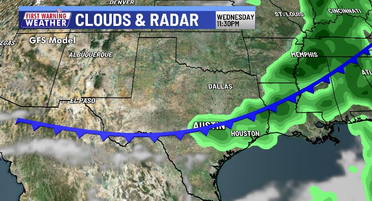
Next cold front brings low rain chance midweek

AUSTIN (KXAN) — Our next weather-maker comes in the form of a weak cold front midweek… while the weather leading up to the front gets a bit uncomfortable.
Today will look and feel similar to what we had this weekend — more sunshine than clouds, afternoon highs in the low 90s and dry skies areawide. Light winds out of the southeast will reach 5-10 mph with a slow climb in humidity expected.
Humidity will continue to steadily increase through Wednesday leading up to our next cold front. In addition to the spike in humidity, temperatures will also take a slight jump with afternoon highs near 10° warmer than average in the mid-90s Wednesday afternoon.

This front has the potential to bring a few spotty showers with it late Wednesday, however, this won’t be a washout. Only some forecast models are indicating rain and even those that are ony indicate light amounts. Wednesday night will be our best opportunity for rain as the front passes over the area. Drier skies will quickly follow by Thursday.
As of now, ACL Weekend 2 is trending dry and warm under a partly sunny sky.
FIRST WARNING WEATHER: Stay up to date with your Central Texas forecast, sign up for our weather newsletter at kxan.com/newsletters
Summer Heat
Meteorological summer ended on Aug. 31, as Camp Mabry recorded its second-hottest summer in recorded history. Austin-Bergstrom recorded its 7th-hottest summer on record.
Preliminary data indicates the entire state of Texas recorded its second-hottest summer on record this year.
Other stories you may like
Sign up for our daily forecast newsletter at kxan.com/newsletters. Download the KXAN Weather app to get the latest weather forecast: Apple | Android
___________________________________________________________________________________________
Follow the KXAN First Warning Weather team on Facebook, Twitter and Instagram.
You can also follow our meteorologists’ individual accounts for livestreams and a little bit of what goes on behind the scenes:


