Quiet New Year’s Day followed by storm chance
AUSTIN (KXAN) — Happy New Year from all of the First Warning Weather Team!
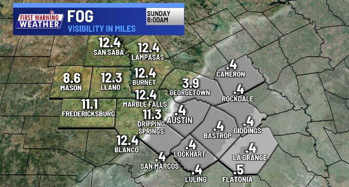
A few hours after midnight some fog could develop, especially along and east of I-35.
The fog will burn off between 8 and 11 a.m. for those that see it, but be ready for low visibility if your travels happen early.

The rest of your New Year’s Day will feature of a mix of sun and clouds along with warm and muggy air. 80s are possible in the Hill Country where fog is lacking, however our Eastern Counties may only reach the low 70s where the clouds are more stubborn.

Tracking Next Storm System
An upper-level area of low pressure along with a Pacific cold front will combine for some showers and thunderstorms on Monday. Our best chance of rain appears to be Monday morning with streamer showers and then again late Monday night when the cold front pushes through.
The rain should be light during the morning, but thunderstorms late Monday night into the first few hours of Tuesday could bring some heavier downpours to areas near and east of I-35.
There’s a “marginal” (1 out of 5) severe weather risk for our Eastern Counties for Monday night into early Tuesday.

Once the front clears we’ll notice temperatures dropping from the 80s on Monday to the 70s Tuesday/Wednesday and 60s by Thursday.
Driest Year Since 2011
The rain gauge at Camp Mabry has measured 26.59″ this year — 10 inches shy of typical rainfall. 2022 will be the driest year since 2011 when only 19.68″ was recorded. In 126 years of record, 2022 will go down as the 31st driest.
8th-Warmest Year on Record
Austin’s 2022 average temperature is 71.1°. This is the the eighth warmest year on record barely behind #7’s 71.2°. The warmest year ever? 2017 with an average temperature, the combination of daily highs and lows, of 72.1°. Camp Mabry has 125 years of record-keeping.
More 2022 notable stats
44th (tied) snowiest year: 0.1″
29th fewest days with measurable precipitation (72 days)
3rd hottest high temperature (110º). Two separate year’s we’ve reached 112º.
14th (tied) hottest minimum temperature (80º)
3rd (tied) most number of triple digit days (68)
1st (tied) most number of 90º or hotter days (164)
1st: Number of days with low temperatures of 70º or warmer (147)
Stay up-to-date with the First Warning Weather team
Follow the KXAN First Warning Weather team on Facebook, Twitter and Instagram.
You can also follow our meteorologists’ individual accounts for livestreams and a little bit of what goes on behind the scenes:


