


Ian becomes a hurricane again, continues path up the East Coast
………………..
Thursday, Sept. 29 Tracking Timeline
11 p.m. Update:
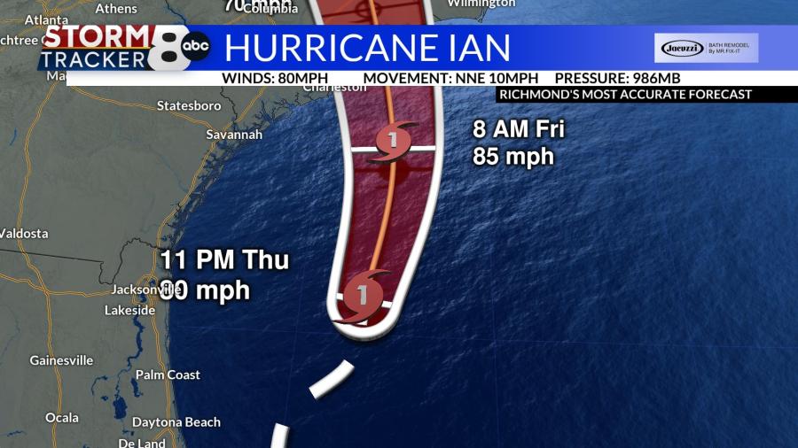
RICHMOND, Va. (WRIC) — The future track for Hurricane Ian has shifted about 30 miles north, meaning that it is likely to make landfall closer to Georgetown, South Carolina, than Charleston, South Carolina.
Ian’s maximum sustained winds are currently 80 mph and it is currently traveling north-northeast at 10 mph.


When the storm makes landfall, it is expected to travel inland near Florence South Carolina by late in the evening. It will then cross into North Carolina and be near High Point by Sunday morning.

The storm will start to fall apart over southwestern Virginia. The effects on the metro Richmond area are not expected to be especially different from Stormtracker 8’s previous predictions.
The rain shield will extend more to the north so there may be a slight increase in rainfall from Friday through Saturday. There could also be a higher risk of seeing wind gusts between 35 and 40 mph over the area.

The worst of the Central Virginia weather will be from late Friday afternoon into Saturday morning. It looks as though it will not pour all day Saturday, but instead change to more drizzly conditions. The remnants of Ian will not be done bringing showers until Sunday and Monday.
5 p.m. Update:
RICHMOND, Va. (WRIC) — Ian has been upgraded to hurricane status once again, according to the National Hurricane Center. It is currently moving toward the Carolinas and Georgia at a speed of 10 mph.


This storm will track to a landfall tomorrow near Charleston, South Carolina, at around midday on Friday — close to where Hugo made landfall in 1989.

The storm will then move to the northwest over Columbia, South Carolina, then Charlotte, North Carolina, and finally end up near the Virginia and Kentucky border.
Hurricane Warnings are in effect for the coastlines of the Carolinas and Georgia.

In Virginia, a Storm Warning is in effect for the lower part of the Bay and Hampton Roads. Northern parts of the Bay are under a Gale Warning as in the lower part of the Maes River. For areas along the Bay, there is also a Wind Advisory in effect.
Central Virginia will have sustained winds that pick up to 20 mph tomorrow afternoon with gusts to near 35pm. The rain will start to pick up in the afternoon and could be moderate to heavy at times Friday evening.


Due to some dry air being pulled in on the east side of the storm on Saturday, Central Virginia should only have spotty rain in the area. Then showers will return on Sunday and Monday.


4 p.m. Update:
RICHMOND, Va. (WRIC) — Tropical Storm Ian is back over the Atlantic Ocean and expected to be over the Gulf Stream until Friday.
During its time over the Gulf, Ian is expected to inch back up to a Category 1 hurricane before making its second landfall near Charleston, South Carolina. From there, the storm will make its way northwest over Columbia, South Carolina, and Charlotte, North Carolina, before finally ending up near the Virginia and Kentucky border.
By the time the storm reaches Central Virginia, it will have lost all tropical characteristics. However, the combination of a northern fair-weather system and Ian will cause some strong winds along Virginia’s coast. Breezy and rainy conditions are expected to begin in Virginia by midday tomorrow and pick up in the afternoon.
PHOTOS: Destruction across Florida in the wake of Hurricane Ian
2:15 p.m. Update:
The National Hurricane Center has issued a tropical storm warning and storm surge watch for the Outer Banks along the coast of North Carolina. The announcement comes before the impacts of Hurricane Ian can be felt in the Carolinas. Watch live webcams of the Outer Banks area here.
12:50 p.m. Update:
RICHMOND, Va. (WRIC) — Ian has downgraded from a hurricane to a tropical storm. The storm now has winds of 70 miles per hour, which means it has strengthened a bit during the Thursday morning hours.
The storm is continuing to move through eastern Florida, and over the next six hours will slide into the Atlantic Ocean. According to the National Hurricane Center, Ian will continue to strengthen as it travels across the water, regaining its hurricane status as a category one, before making a second landfall between Beaufort and Charleston, South Carolina Friday morning. Hurricane warnings are in effect for the South Carolina coastline. Tropical storm warnings are in effect for most of North Carolina.
Once Ian makes that second landfall it will start to fall apart again, lowering in intensity to a tropical depression, and then a remnant low by Saturday evening. The moisture out ahead of Ian will work into central Virginia, causing rain throughout the weekend.

One of the big factors that will happen as Ian begins to move onshore into South Carolina is the winds that will form between Ian and an area of high pressure to the North. This will create some pretty strong northeast winds over the Atlantic Ocean and into the Chesapeake Bay. Because of those winds, a Gale warning has been issued for the coastal waters of Virginia.
WEDNESDAY COVERAGE: Hurricane Ian makes landfall in Florida
Virginia could be looking at winds of 35 to 46 miles per hour in the Atlantic Ocean and 29 to 40 miles per hour in the Chesapeake Bay.

This will create some minor storm surges along the Northern Neck, the Middle Peninsula, the Lower Peninsula and tidal rivers. Most of that storm surge will be about one to two feet. However, along the Eastern shore of Virginia, the storm surge, due to the ocean waves, could be as much as 3 to 6 feet.
It is important to mention that while the winds will be strong over the ocean and in the Chesapeake Bay we are only looking for ten to 20-mile-per-hour winds across central Virginia.
Virginia State of Emergency declared by Youngkin in advance of Hurricane Ian
Rain will develop Friday morning from south to north, and it looks as though most of central Vigrinia will see rain by the lunch hour Friday. It will be a cool day with highs only in the upper 60s.
Steady to possibly heavy rain at times will occur Friday evening and Friday night, with the possibility of lingering into Saturday morning. Overnight lows will fall back into the upper 50s.

Rain by Saturday 4pm

Total Rainfall by Tuesday Morning at 7am
Steady rain Saturday morning will taper to showers, and it will be a wet day with showers continuing off and on throughout the day. It will remain cool with highs only in the middle to upper 60s.
More showers are likely for Sunday with temperatures remaining in the upper 60s.
Monday will be wet once again as showers will be across central Virginia with highs in the middle 60s.
Finally, any showers early Tuesday morning will move off the coast and partly sunny skies should return for the afternoon. It will remain cool with highs in the middle 60s.